CREATING A ‘NEIGHBORHOOD MAIN STREET’ FOR THE PINEHURST STATION AREA
Roosevelt Way N is overbuilt for vehicles and underbuilt for pedestrians.
Roosevelt Way N is a diagonal thoroughfare that connects neighbors across the north Haller Lake neighborhood, between Aurora and I-5. It is also the flattest, most convenient route to access the new light rail station. With a new pedestrian/bike crossing at N 137th Street & Aurora Ave N coming in the next year, Roosevelt Way will be the primary connecting route for neighbors west of Aurora who bike, walk or roll to the station when it opens in 2026.
Despite its unique advantages, Roosevelt Way today is not safe for biking or walking. The roadway consists of two 11’ vehicle travel lanes, with a dirt shoulder in some places and an open ditch in others. Due to the diagonal street cutting through the N-S grid pattern, several intersections along the corridor are large and unwieldy—notably the Meridian Ave N / N 137th St / Roosevelt Way N intersection. This intersection has a couple driveways that open onto the intersection, making it seem like a 7-street intersection resulting in confusing traffic.
Building full sidewalks where there is an open ditch is currently cost prohibitive with the city's budget. We propose creating a safe pedestrian walkway on the already paved roadway. We anticipate minimal costs to convert the 22’ right-of-way set aside for cars into a 14’ car lane and two 4’ bike/walk paths. This would bring the travel lane width in line with vehicle travel lanes on typical residential streets that have sidewalks and cars parked on both sides.


A Strategy for Realizing the Roosevelt Main Street
- De-arterialize Roosevelt Way N: Change the roadway’s official designation from “Collector Arterial” to “Neighborhood Yield Street.” This will allow for traffic calming treatments like speed humps and narrowed lanes.
- Narrow the travel lane: Asimple re-painting of the roadway to convert two 11’-lanes into one 14’ residential access lane (see Roosevelt Way N image below).
- Restrict north-south cut-through traffic: Create ‘right-in, right-out’ restrictions at each of the minor intersections perpendicular to Roosevelt Way, at Corliss, Wallingford, and Ashworth
- Install roundabouts at two main intersections:
- At 143rd & Roosevelt
- At 137th & Roosevelt & Meridian (see N 137th St image below).
- Included in Transportation Levy: “Crossing Improvements ($14M) • Make improvements at street crossings, including upgraded crosswalks, visibility improvements, pedestrian crossing signals, and more. Initial projects are expected to include: » 5th Ave NE and NE Banner Way » Rainier Ave S and S Henderson St » 35th Ave NE » 11th Ave E and E Aloha St » N 137th St and Roosevelt Way N”
- at Roosevelt & 1st Ave NE
- Install pedestrian lighting

Expected Outcomes
If implemented, the Roosevelt Way Main Street will facilitate safe, comfortable, convenient, and simple connections to the future light rail station. Students, staff, and family members of Ingraham High School, and Lakeside High School and Middle School will be able to safely access the light rail network. Residents in Bitter Lake will be able to ride a bike home safely and conveniently from the station. Haller Lake neighbors with children in strollers or those in wheelchairs will feel safe walking and rolling to get to the station.
Aligning with One Seattle
When the Pinehurst Link Light Rail Station opens in 2026, neighbors will be traveling to and through the station area from as far away as Lake City to the east and Broadview to the west. With no car parking at the new station, transit and biking/walking connections will be crucially important for maximizing ridership at the station.
Moreover, with the station area being upzoned into an entirely new Urban Center, the number of neighbors moving through the station area will increase significantly in the next 5-10 years. The more safe biking and walking connections we build through the neighborhood, the more neighbors living near the station will choose low- and zero-emission modes of transportation.
In fact, the city already identified Roosevelt Way N as a key corridor in the 2020 Multimodal Access Study, calling for a Neighborhood Greenway and Shared Use Path. Building out critical transportation infrastructure in the new station area will support the city’s goals of reducing vehicle miles traveled and achieving zero traffic fatalities.
Connecting to an I-5 Lid Project
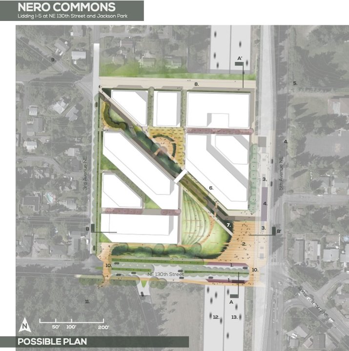
In the 2024 Levy to Move Seattle the levy included $500,000 to study lids over I-5 in the University District and 130th Street / Pinehurst Station areas. In 2017 a UW landscape architecture student drafted a design concept for a lid over I-5 at the new light rail station. In this concept the diagonal Roosevelt Way N is extended onto the lid and connects directly to the station. Any future lid project will undoubtedly seek to connect to Roosevelt Way, highlighting the importance of transforming this corridor into a neighborhood main street.
