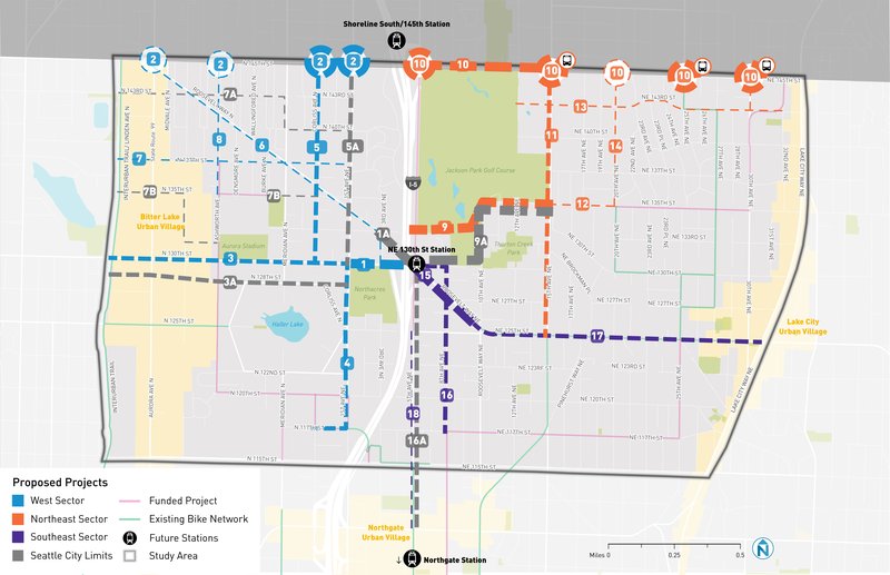
Northwest Greenways' Preferred Pedestrian / Bike Routes to new LINK Light Rail Stations at 130th and 148th Streets
As soon as next year the transportation options for North Seattle are going to change dramatically. Residents need safe options to walk, ride, roll, and push strollers to and from the future Shoreline South/148th St station (2024) and the NE 130th St station (2026). Northwest Greenways has studied options for walking / riding / rolling to the stations and provided 8 recommendations for SDOT. These are largely drawn from the city’s 2020 Multimodal Access Study.
If implemented, NW Greenways’ prioritized projects will facilitate safe, comfortable, convenient, and simple connections to the future light rail stations.
- Students, staff, and family members of Ingraham High School, Lakeside High School and Middle School, and Northgate Elementary School will be able to safely access the light rail network.
- Residents in Bitter Lake will be able to ride a bike home from the station using the Interurban Trail.
- Haller Lake neighbors with children in strollers or those in wheelchairs will feel safe walking and rolling along the sidewalks and crossings to get to the stations.
- Pinehurst residents will be able to safely walk, bike and roll on 8th Ave NE and cross Roosevelt Way NE to access the NE 130th Street Station.
- Neighbors east of I-5 will be able to more safely access the Interurban Trail.
Our Recommended Improvements
N 130th St from The Interurban Trail to 5th Ave NE (Map #3 & #1)
The redesign of N 130th St. must include an all ages and abilities bike route and sidewalks with accessible curb cuts. For Area 1 on the map, between 1st Ave NE and 5th Ave NE, we recommend a widened two-way shared path on the north side of the street to allow east and west-bound bicyclists and pedestrians access to the station and to connect to 1st Ave NE, which will be a primary biking and walking route from the south. Walking or biking on the south side of 130th is much more dangerous due to the I-5 entrance and slip lanes. Every signalized intersection along the corridor needs to have leading pedestrian intervals so that people walking and rolling across these intersections get a head-start on the traffic.
In addition, ensure good travel speeds for buses by adding BAT lanes and queue-jumps as necessary along the 130th/Roosevelt/125th corridor.
Roosevelt Way N from 3rd Ave NE to N 143rd and west to the Interurban Trail (Map #6)
This flat street should become a calm Greenway connecting Bitter Lake and Interurban Trail users to the 130th St Station. All cross street intersections currently have stop signs.
We recommend restricting traffic on 3rd Ave NE at its intersection with N 130th to allow safe walking and riding between N 130th and Roosevelt Way N. A simple street end like at Ashworth and 130th would be effective. Neighbors and businesses near the intersection support this idea.
As the station area attracts density and more vehicles, we anticipate an increase in traffic on the major N-S streets. We recommend improving the crossings at Roosevelt Way N and 1st Ave NE and at Roosevelt Way N and Meridian Ave N.
Aurora Avenue is a divider. The Bitter Lake neighborhood has advocated for generations to reconnect the community and create safe crossings over Aurora. We recommend adding a signalized crossing at N 143rd St across Aurora Ave N.
Improved walking / biking conditions on the very densely-populated stretch of N 143rd St from Aurora Ave N to the Interurban Trail / Linden Ave N will also be needed. Major new housing developments are currently under construction along 143rd which will make this crossing even more important.
Learn more about our vision for the "Roosevelt Way Main Street."
N 128th St from 1st Ave NE to the Interurban Trail (Map #3A)
This street should become a Greenway safely connecting Bitter Lake residents and Interurban Trail users to the 130th St Station.
We recommend improving the intersection of N 128th St & Corliss Ave N for safe crossing and adding a signalized crossing at N 128th across Aurora Ave N.
1st Ave NE (Map #4)
Add a bike lane to the east side of 1st Ave NE, from N 117th to N 130th.
Improve the crossing at N 128th & 1st Ave NE.
Roosevelt Way NE (Map #15)
Adding protected bike lanes on this stretch of Roosevelt Way NE is essential.
8th Ave NE from N 117 to NE 130th St (Map #16)
The 8th Ave Greenway should be extended north to provide a safe connection to the N 130th Station.
Add a signalized crossing at Roosevelt Way NE so that both bikes and pedestrians will have safer access to the station via NE 130th by using this crossing.
Corliss Ave N (Map #5)
This residential street should become a Greenway, connecting easily to both the 130th and 148th St Stations. All but one intersection already have traffic calming circles or stop signs at cross streets.
A signalized crossing at N 145th St would allow pedestrians and cyclists safe access to the north side of N 145th St and would separate them from the traffic on 1st Ave NE. Shoreline has shown plans for a wide shareway on the north side of N 145th St to the station. This shareway will prove a safer way for pedestrians, scooters, and bikes to reach the future roundabout at N 145th St & I-5 by crossing one lane of traffic one time. The roundabout crossing on the south side of 145th will require multiple crossings across the southbound freeway entrance ramp and then across 5th Ave NE and 145th to reach the station.
The Corliss Greenway can easily continue in Shoreline to N 148th St and then east to the future Pedestrian / Bicycle I-5 overpass to the N 148th St. Station.
Ashworth Ave N (Map #8)
Anticipating Ashworth Ave N becoming a safe way to cross N 130th Street, we recommend extending the Ashworth Greenway to 145th Street and creating a convenient grid of safe all ages and abilities bike routes in the North Haller Lake neighborhood.